Into the Monsoon Seas: A Chronicle of the Scripps Expeditions to the Indian Ocean, 1960–1963
A narrative journal of the Monsoon and Lusiad Expeditions of the Scripps Institution of Oceanography, University of California, San Diego — reconstructed from the preliminary report of the members of the expedition, edited by Robert L. Fisher, 1964.
Prologue: The Last Unknown Ocean
In 1959, when the world’s great powers were racing to put satellites into orbit and planting flags on the lips of the stratosphere, a quieter but no less consequential race was underway at sea level. The Indian Ocean — the third-largest body of water on Earth, cradle of ancient trade routes, mythologized in Arab, Persian, and Chinese seafaring literature for millennia — remained, in a scientific sense, profoundly unknown. Its depths had never been properly sounded. Its internal currents were largely a matter of conjecture. The structure of its seafloor crust, the heat bleeding through its sediments, the chemistry of its deep waters — all of this lay in darkness.
The Scientific Committee on Oceanic Research (SCOR) and UNESCO had recognized this gap and called for a coordinated international program: the International Indian Ocean Expedition, an ambitious multinational effort to drag the Indian Ocean out of the scientific shadows and into the light of modern oceanography. Among the institutions that answered this call was the Scripps Institution of Oceanography (SIO) of the University of California, San Diego — and the expeditions they sent would become some of the most remarkable ocean voyages of the twentieth century.
What follows is the story of those voyages: the Monsoon Expedition of 1960–1961, and the Lusiad Expedition of 1962–1963. It is a story of mechanical breakdowns and medical emergencies, of volcanic spectacles and sub-Antarctic storms, of seamen and scientists sharing a ship for months at a time in waters that no research vessel had properly charted before. It is, above all, the story of human beings pushing into the unknown with instruments, notebooks, and an insatiable curiosity about the world beneath the sea.
Part I: Monsoon — The First Venture (1960–1961)
Chapter 1: Casting Off from San Diego
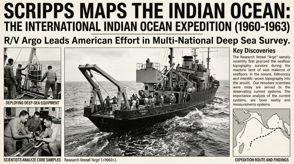
The R/V Argo sailed from San Diego on the morning of August 26, 1960, carrying the University of California’s first oceanographic scientific party into the Indian Ocean. She was a recently reactivated and newly converted research vessel — not yet fully trusted by the sea — under the command of Captain Laurence E. Davis and guided scientifically by George G. Shor Jr., a seismologist who led a party of twenty scientists. The group was a mixed gathering of physical scientists and two ichthyologists, the latter aboard not for fish per se but to conduct airborne insect, plankton, and fish collections — one of those delightfully improbable combinations of expertise that oceanographic expeditions so often produce.
The planned route was a sweeping arc from San Diego to Suva, Fiji, and then on toward the Indian Ocean proper via Australia. From the very outset, however, Argo reminded her crew that she was a vessel still finding her sea legs. The ship’s electrical circuits and machinery were troublesome. The winches — critical to the entire scientific enterprise of lowering instruments thousands of meters into the ocean — were particularly unreliable. These were not merely inconveniences; on a scientific expedition of this kind, equipment failure meant data not collected, stations not occupied, months of careful planning going unrealized.
The first serious crisis came early. Near 13°N, 145°W, just one week into the voyage, Argo‘s starboard steering cable nearly parted — a potentially catastrophic failure at sea. The ship was forced to divert to Honolulu for repairs, arriving on September 6 and not departing again until the 17th. The unplanned eleven-day stop forced the abandonment of Suva from the itinerary. It was a bitter early lesson in the gap between expedition plans drawn up in the calm of a California office and the reality of life aboard a vessel at sea.
Departing Honolulu on September 17, Argo set course for Cairns, Queensland, via Howland and Nanumea Islands. On this long Pacific crossing, the ship’s scientists were not idle. They ran short seismic refraction lines, took 21 gravity cores, made 11 temperature probe lowerings, conducted 7 camera station dives, and logged 247 bathythermograph readings. When the ship crossed the Equator at exactly 180° longitude — that curious cartographic point that is simultaneously neither east nor west — fourteen crew and scientists were initiated as “shellbacks” in the time-honored maritime ceremony.
There was also genuine discovery along the way. On October 1, crossing the North New Hebrides Trench near Vanikoro Island — the site, incidentally, where La Pérouse’s ships Astrolabe and Boussole had been wrecked a century and a half earlier — Argo confirmed a trench bottom at an astonishing 4,695 fathoms uncorrected, roughly 1,100 fathoms deeper than previously accepted figures. This single sounding would later be confirmed and extended by further exploration, but it was the first hint that Argo‘s Pacific crossing was already producing science of consequence.
Chapter 2: The Banda Sea and the Approach to the Indian Ocean
Argo reached Cairns on October 6 for a critical resupply and personnel changeover. Here the ship made arrangements that would define the character of the first great Indian Ocean phase of the Monsoon Expedition: the charter of M/V Malita, under Captain Bert Cummings, to serve as a primary shooting vessel for seismic refraction work. The logic was simple but important — to properly measure the structure of the Earth’s crust beneath the ocean, one vessel fires explosive charges while another, positioned miles away, listens for the seismic waves that travel through rock and sediment. Two ships are required, and Malita would be Argo‘s indispensable partner through the Indonesian island chains.
The two ships departed Cairns and transited the treacherous Torres Strait on October 10, making their way into the complex waters northwest of Australia. The next several weeks would be a sustained immersion in one of the most geologically complex regions on Earth: the Indonesian archipelago, where the Australian tectonic plate grinds against the Eurasian plate and erupts into a tangle of deep trenches, volcanic islands, and enclosed basins of extraordinary depth.
They occupied seismic stations in the Weber Deep, that immense basin north of Timor reaching nearly 3,800 fathoms, testing Argo‘s recently repaired dredging winch by lowering a gravity corer and then attempting an otter trawl in which the ship paid out a staggering 12,000 meters of wire. The trawl probably never touched bottom — the ocean was simply too deep — but the winch had been tested and found reliable. It was the kind of practical knowledge, mundane in description, that could mean the difference between scientific success and failure when the ship reached deeper targets ahead.
Then came Port Darwin, arrived at on October 17, and the beginning of the expedition proper.
Chapter 3: Fire and Deep Water — The Indonesian Transect
From Port Darwin, Argo and Malita pushed into the heart of the scientific program. The aim was nothing less than a re-examination, using modern equipment, of the crustal structure of the Indonesian island arc — the volcanic chain that had obsessed geologists since Dutch researchers had first mapped the gravity anomalies here. Those anomalies had been among the most important clues in the development of theories about island arcs, deep-sea trenches, and the forces that build mountain ranges.
Argo now brought new tools: seismic refraction measurements capable of probing down to the Earth’s mantle, heat flow sensors to detect the warmth bleeding up from the planet’s interior, precision depth recorders, and continuous gravity and magnetic observations. The work was meticulous, exhausting, and frequently thwarted by equipment failures and rough seas. The loss of a stereo camera system on its thirteenth lowering — along with 6,620 meters of tapered dredging wire, when the cable was pulled apart through mechanical error — was a particularly frustrating setback. But it was met with quiet resilience: improvisation. The camera’s operator, Shipek, assembled two other units from spare parts and continued his program; the large wire was respliced; within days, the work continued.
The transects conducted off Bali and central Java over the following weeks revealed a geological world of astonishing complexity. Off Bali, from south to north, the team observed seismic velocities down to the mantle across a 325-mile section that included the wide, flat Wharton Basin, the steep flanks of the Indonesian Trench (reaching depths of 3,400–3,550 fathoms), the ridge separating the trench from the Bali Trough, and the trough itself, smooth-floored and sediment-blanketed at about 2,305 fathoms. Off central Java, the geology differed in revealing ways: the island shelf was wider, the Bali Trough narrower, and the Indonesian Trench itself reached 3,720 fathoms, with a distinctive flat bottom bordering an axial knoll. Photography from the trench floor — 3,350 fathoms below the surface — showed rock outcrops visible in images taken by camera lowered on wire.
It was while anchored in the lee of Bali between stations that the biologists took advantage of calm water to dip-net sea snakes from the shallows — three species, the largest more than four feet long and as thick-bodied as a rattlesnake, hauled aboard for the collections.
Chapter 4: Krakatau at Night
Argo sailed from Djakarta (Jakarta) on November 18, bound across the Indian Ocean. By late afternoon she had reached the western side of Sunda Strait and a geological spectacle that no amount of scientific planning could have scheduled: just at dusk, the ship crossed the submerged south rim of Krakatau’s caldera — the remnant of the catastrophic 1883 eruption that had sent a shockwave around the world — and came within two miles of Anak Krakatau, the “child of Krakatau,” the parasitic volcanic island that had grown up from the destroyed caldera in the 1920s.
In the failing equatorial light, Anak Krakatau was performing. Fire bursts from its summit illuminated the sky periodically. Large blocks of volcanic rock were being ejected into the air and falling back into the sea. The ship’s company lined the rails to watch. Below, in the scientific lab, hydrophones were streamed and the water-borne sounds of the eruption were recorded — the crack and rumble of volcanic outgassing traveling through the sea, captured on magnetic tape.
It was the kind of moment that scientific reports struggle to convey: the intersection of the vast geological forces that the expedition had been measuring in rock and sediment, suddenly manifest in light and fire and sound.
Chapter 5: The Central Indian Ocean — Crossings of the Median Ridge
With Krakatau behind her, Argo turned west toward the open Indian Ocean. Over the next three weeks, she would make four separate crossings of the Mid-Indian Ocean Ridge system — the seismically active mountain range that bisects the Indian Ocean in the shape of an inverted Y — a feat of systematic geological reconnaissance entirely new to science.
The crossing between 14°S, 72°E and the island of Mauritius proved the most illuminating. The ridge here was revealed as enormously broad — 450 to 550 miles wide — and possessed of the kind of violent topography associated with active volcanism: magnetic anomalies, volcanic sands in the cores, dredged volcanic fragments, and bottom photographs showing rock outcrops. But crucially — and this would fuel decades of subsequent debate — no single obvious central rift valley was found. The “rifted” topography lay in a strip about 100 miles wide, centered near 15°45’S, 67°55’E, offset from the earthquake epicenter strip that geologists had mapped from a distance.
Norris Rakestraw, one of the expedition’s chemists, was meanwhile building a profile of radiocarbon concentrations at stations along 75°E — a north-south chain of measurements that would eventually give oceanographers a window into the deep circulation patterns of the Indian Ocean, the slow drift of ancient water masses that had last seen the surface centuries ago.
The arrival in Port Louis, Mauritius on December 7 marked the end of the first open-ocean leg. Three days in port gave scientists and crew alike the chance to walk on solid ground and eat fresh food. Four scientists scaled Pieter Both, the island’s most dramatic landmark at 2,690 feet. Others were received at luncheon by Sir Colville Deverell, the Governor-General. The gravity specialists, ever duty-minded, drove a rented car around the island making measurements at the fuel dock and at La Plaisance Airport. An open house aboard Argo in the harbor drew almost 100 members of Mauritius’s government, commercial, and scientific communities — a reminder that these expeditions were not merely scientific enterprises but diplomatic ones too, vessels of exchange between the institutions of oceanography and the peoples of the Indian Ocean world.
Chapter 6: Southern Waters — Saint Paul Island and the Approach to Australia
Leaving Mauritius, Argo turned south and east toward one of the strangest corners of the southern Indian Ocean: the remote volcanic islands of Saint Paul and Amsterdam, French possessions sitting equidistant between Madagascar and Australia, entirely outside modern shipping lanes, visited perhaps a dozen times in the previous century. The geology of Saint Paul Island rested largely on the observations of Ferdinand von Hochstetter, who had spent eighteen days there in 1857 during the Austrian circumnavigation aboard the frigate Novara. The last published nautical chart of the island had been based on a French survey conducted in 1874 — by scientists who had gone there to observe the Transit of Venus.
Argo anchored at Saint Paul in the late afternoon of December 23, off Rocher Quille (Ninepin Rock), beside the breached cobble spit that nearly closes the ancient volcanic crater. A shore party of six was put ashore to measure gravity and make geological and biological collections. Argo‘s utility boat was piloted through the narrow channel by boats from a French lobster vessel, Sapmer, whose captain mentioned that a French motor vessel, La Parisienne, had sunk in that same channel more than forty years earlier, her boiler lying just two feet below the surface at low tide.
Overnight, while the shore party camped among the ruins of the abandoned lobster cannery (shuttered since 1928), Argo made a seventeen-hour survey of the island’s surroundings, measuring depths, magnetic intensity, and gravity. The submarine topography was immediately significant: the seafloor dropped steeply immediately to the east of the island, confirming that the entire eastern section of the volcanic structure had been removed by faulting; to the west, north, and south, narrow shelves and submerged lava flows were plain in the echo-sounder trace.
After the shore party returned — with rock samples, trapped insects, and carcasses of black rabbits, swallow-tailed terns, and yellow-crested rockhopper penguins — and after Captain Barbenton of Sapmer had lunched aboard and the ships had exchanged Christmas tokens, Argo headed southeast. A subdued shipboard Christmas Eve dinner featured bisque and lobster tail — courtesy of Sapmer‘s catch — as the pensive ship’s company watched the volcanic island recede into the darkness.
The run toward Fremantle continued to produce science. On December 31, Argo recorded depths of 3,400–3,467 fathoms for several miles near 35°37’S, 103°50’E — an unnamed deep that no vessel had previously documented. After a subdued shipboard New Year’s celebration in rough seas approaching Western Australia, Argo docked at Fremantle on January 2, having run 4,800 miles since Port Louis.
After brief stops in Fremantle and Hobart (where Captain Davis was hospitalized with hepatitis, first officer Hansen serving as master for the onward passage), and after a crossing of the Tasman Sea to Wellington, Argo continued into the southwestern Pacific for an eleven-week geological survey before returning to San Diego on April 18, 1961 — 235 days and 38,600 miles after departure.
Forty-five scientific party members had served aboard Argo during the Monsoon Expedition. Of these, only five had made the entire voyage.
Part II: Lusiad — The Great Expedition (1962–1963)
Chapter 7: An Epic Poem for an Epic Voyage
The name of the second Scripps Indian Ocean expedition was borrowed from Portuguese literature. Os Lusíadas — “The Lusiads,” celebrating the people of Lusus (ancient Portugal) — is the great epic poem of Luís de Camões, written around 1572. It celebrates the voyages of Vasco da Gama and the Portuguese navigators who first opened the sea routes of the Indian Ocean to European trade: men who sailed blindly into monsoon seas by the stars alone, with no depth sounders, no radiocarbon dating, no gravity meters. The choice of name was not merely poetic gesture. It was a declaration of kinship with those earlier wanderers — an acknowledgment that the scientists aboard R/V Argo and R/V Horizon were doing something that partook, however modestly, of the spirit of discovery that had driven ships into these waters for five hundred years.
The Lusiad Expedition was a far larger undertaking than Monsoon. Where Monsoon had lasted three and a half months in the Indian Ocean, Lusiad would spend eleven and a half calendar months — nearly a full year — in those waters. Where Monsoon had been primarily a one-ship operation, Lusiad would be largely a two-ship affair, with Argo and Horizon working in coordinated tandem across thousands of miles of open ocean. The scientific programs were correspondingly more ambitious: equatorial current studies across the full breadth of the ocean during both monsoon phases, extended geological and geophysical profiling of the seafloor and the crust beneath it, systematic radiocarbon profiling of the water column, and sustained atmospheric CO₂ measurements that were then at the scientific frontier.
Lusiad was also a joint operation between the University of California and the University of Rhode Island, with the equatorial current studies planned and directed by John Knauss of URI’s Graduate School of Oceanography. The international dimension was striking as well: UNESCO Fellows from the United Arab Republic, India, Pakistan, Israel, Indonesia, China, and other nations sailed with the expedition at various stages, part of a broader effort to build oceanographic expertise in the countries that bordered the Indian Ocean.
Argo sailed from San Diego on May 15, 1962, with nine scientists aboard, under the command of Captain Alan Phinney. Horizon, meanwhile, was making her way to the Indian Ocean from the Atlantic, passing through the Mediterranean and Red Sea.
Chapter 8: The Equatorial Undercurrent — Finding the Hidden River
The first great scientific chapter of Lusiad was also the most immediately oceanographically significant. Between late June and late September 1962, Argo traversed the equatorial Indian Ocean under John Knauss’s direction, making hydrographic stations at two-degree intervals, planting current-measuring buoys, and deploying Swallow floats — neutrally buoyant instruments designed to drift at a chosen depth and be tracked acoustically to reveal subsurface current velocities.
The scientific question driving this program was profound: did the Indian Ocean possess an Equatorial Undercurrent? In the Pacific and Atlantic, oceanographers had discovered a remarkable hidden feature — a strong, narrow, eastward-flowing river of water embedded within the upper thermocline, sandwiched between the westward-flowing surface currents above and the calmer deep water below. This “Cromwell Current” in the Pacific flowed at speeds reaching 125 cm per second, entirely invisible from the surface, one of the ocean’s great hidden phenomena. Did the Indian Ocean, with its unique monsoon-driven circulation that reverses direction seasonally, harbor a comparable feature?
The measurements were complicated from the start. The loss of the primary Hytech current meter — its suspension cable corroded by electrolysis until it simply failed under the instrument’s weight — forced the scientific party to fall back on a Roberts current meter of inferior quality. Ship stops in Mombasa and Port Victoria, personnel changeovers, equipment failures: none of this prevented the systematic collection of data. Four meridional cross-sections of the ocean, each spanning from 5°N to 5°S at one-half-degree station intervals, were occupied at longitudes of 53°E, 62°E, 79°E, and 89°E, with current measurements at depth supplemented by full hydrographic casts.
The result, when the data was processed ashore, was startling — and had in fact been missed during the cruise itself, because the scientific party simply did not have time to fully process the observations before reaching Cochin. At longitudes of 79°E, 89°E, and 92°E, the data showed the unmistakable signature of an Equatorial Undercurrent: eastward flow in the thermocline, centered on the equator, with a core velocity reaching 80 cm per second at the 92°E section in April. The current structure was stable over periods of at least a week. The maximum eastward speeds were, as expected, located precisely at the equator, with the north-south components remaining small in comparison. This was the Indian Ocean equivalent of the Cromwell Current — a discovery of the first order. The Indian Ocean Equatorial Undercurrent had been found.
The second phase of the current studies, conducted between February and May 1963, confirmed and extended the finding. During the transition from northeast to southwest monsoon, the Undercurrent was measured continuously from 61°E to 92°E, with maximum speeds reaching 81 cm/sec. The data told a complex story: the Undercurrent was not always present, its amplitude varied strongly with longitude and season, and at the western stations (53°E and 62°E) it sometimes could not be detected above the noise level of the measurements. But the phenomenon was real, and its discovery would reshape understanding of Indian Ocean dynamics for decades.
Chapter 9: Two Ships in the Southern Ocean
While the current studies were underway, the geological and geophysical work of Lusiad was pressing forward on a grand scale. Following Argo‘s first current studies cruise, Horizon joined the expedition at Cochin in late September 1962, and together the two ships began a sustained assault on the geology of the western and central Indian Ocean.
The two-ship seismic refraction program was technically demanding. In ideal conditions, Argo would take up a listening position fifty miles ahead of Horizon along the planned line of advance, her hydrophones streaming and the ship held as quiet as possible. Horizon would run toward Argo, commencing her firing run when forty to fifty-five miles distant, setting off explosive charges of increasing size as the range decreased. After passing Argo, Horizon would continue shooting in the direction of advance, allowing the reversed profile that geophysicists need to properly interpret the seismic data. All the while, Argo would be taking cores, measuring heat flow, making hydrographic casts — the receiving ship had eight to twelve hours on station, and every minute of it was used.
The two ships worked westward from the Laccadive-Maldive Ridge toward the Seychelles, completing reversed refraction stations across the flat plain east of the Chagos Archipelago, along the Chagos Ridge itself, up the eastern flank of the Seychelles Bank, and on the shallow plateau of Saya de Malha. At each station, the seismic arrivals recorded in Argo‘s hydrophones revealed the structure of the crust beneath — the layering of sediment, basalt, and deeper crustal rock, and in the best cases, arrivals from the upper mantle itself, 30 to 40 kilometers below the seafloor.
Port Victoria, the capital of the Seychelles, welcomed both ships. Captain Hopkins of Horizon, ever an enthusiast for the natural world, purchased for the San Diego Zoo a huge female Aldabra tortoise — at 385 pounds, somewhat below her best weight — which proceeded to occupy a corral on Horizon‘s boat deck for the remainder of her time on the ship.
Chapter 10: A Medical Emergency in the Southern Ocean
The most dramatic episode of the entire Lusiad Expedition unfolded in mid-November 1962, south of Saint Paul Island in the wildest stretches of the southern Indian Ocean, far from any port and deep in waters that offered no shelter.
The ships had been working around Saint Paul and Amsterdam Islands — extending and refining the surveys begun on Monsoon — when a crewman on Horizon, David O’Connor, fell extremely ill and required blood transfusions immediately. The nearest hospital was in Fremantle, nearly 1,900 nautical miles to the east. In deteriorating weather — fog, high seas — Argo attempted a small-boat transfer of three blood donors, oxygen, and specialized medical equipment to Horizon while both ships lay in the slight lee of Amsterdam Island. The transfer of personnel succeeded; the reverse transfer, when conditions worsened further, did not. Fisher, the expedition leader, found himself stranded on the wrong ship.
The decision was made: both ships would run at Horizon‘s best speed for Fremantle. But the seas directly ahead were too rough for Horizon to hold a direct course; for twelve hours she ran eastward and southeastward on whatever headings were safe, gradually working into a position from which a direct run for Fremantle became possible. Contact had been established with Australian naval authorities. HMS Cavalier — a British destroyer then in Fremantle for the 1962 Empire Games — was dispatched to intercept.
On the morning of November 21, at a point 1,140 miles from Fremantle, Cavalier drew alongside Horizon in the heavy swell. In a display of rough-water seamanship that impressed everyone watching, Cavalier‘s boat crew managed the transfer of O’Connor and the ship’s physician in conditions that made such operations extraordinarily dangerous. Cavalier reached Fremantle on November 23. David O’Connor was placed in hospital and survived.
The two research vessels reached Fremantle days later, battered and sobered. Scientific work had continued as much as conditions permitted — Argo and Horizon managed a split seismic profile near 34°S, 94°E during the run east — but the human drama of those days overshadowed everything. No one who made that run from Amsterdam Island to Fremantle would forget it.
Chapter 11: The Indonesian Arc — Argo’s Grand Survey
After Christmas at Port Darwin and a crew change, Argo sailed on New Year’s Day 1963 into a phase of the expedition that would rank as one of the most ambitious geological surveys ever attempted in the Indonesian island arc.
For the next six weeks, Argo worked essentially without stopping through the Banda Sea and around the entire Indonesian island chain, making continuous underway measurements of seafloor topography, magnetic intensity, and gravity across the deep basins and trenches of the most geologically complex region in the Indian Ocean. Stops were kept to an absolute minimum — the ship pausing only twice (at Bali and Djakarta) during the entire six-week arc.
The Banda Sea was revealed as a world of extraordinary topographic variety. Argo logged the flat floor of the Weber Deep at 3,805 fathoms, the broad Banda Basin, and the highly contorted bathymetry around the volcanic islands of Ceram. South of Roti and Timor, the ship documented the transition from the shallow inner arc into the Indonesian Trench, with a single flat-bottomed trench crossing at 3,590–3,612 fathoms — flat for one-and-a-third miles at that depth, a remarkable piece of deep-sea geometry.
The Bali Trough — the inner, sedimented depression paralleling the trench from southeast to northwest — was measured on crossing after crossing. At 2,087 fathoms (flat for two and a half miles on one crossing), with the main trench at 3,687 fathoms just to the south and the intervening ridge at 1,710 fathoms between them, the cross-section data painted a detailed picture of how the Australian plate is being subducted beneath Indonesia. Four complete trench crossings south of Bali gave depths of 3,507, 3,513, 3,560, and 3,545 fathoms from east to west — extraordinary precision for measurements made from a moving ship.
From the Moluccas around through the Banda Sea, Flores, Bali, Java, Sunda Strait, and then northwest along Sumatra to the Nicobars, Argo recorded the anatomy of a complete island arc system in unprecedented detail. The progressive shoaling of the trench from 3,440 fathoms off Sunda Strait to 2,401 fathoms northwest of Sumatra was documented on eleven crossings; on every one, a flat trench floor — two to sixteen miles wide — was found.
At Benoa on Bali’s south coast, “nearly all hands” went ashore to visit Den Pasar and tour the island’s temples and rice paddies. At Djakarta, the scientific party met with Indonesian colleagues and government officials, presenting descriptions of their programs and discussing Indonesia’s participation in the broader IIOE. The courtesy calls were as much a part of the expedition as the seismic stations.
Chapter 12: The Bay of Bengal and the Road to Colombo
From Djakarta, Argo ran northwest along Sumatra and then across the Bay of Bengal toward Colombo, Ceylon, making eleven crossings of the trench system off Sumatra as she went. Near the northwest tip of Sumatra and the Nicobar Islands, the topography became more complex — the trench shallowing and the outer ridge system becoming irregular and interrupted.
The Bay of Bengal abyssal plain, crossed on the final run toward Ceylon, was a landscape of extraordinary flatness, the sediment-covered floor sloping westward at gradients as gentle as eighteen fathoms per fifty-five miles. Into this mirror-flat plain, turbidity currents had cut a series of submarine channels and gullies, faintly visible in the echo-sounder traces — structures carved by the downslope flow of sediment-laden water, analogous to rivers cutting valleys on land. The images are striking: low levees flanking the channel axes, accordant terraces visible on either side, all superimposed on the gently westward-sloping surface.
Argo reached Colombo on February 12, 1963, 11,600 miles out of Port Darwin. The intensive geological work in the Indian Ocean was essentially complete.
Chapter 13: Homecoming
The final months of the Lusiad Expedition were a gradual unwinding from the Indian Ocean. After the second current studies cruise — which added the Seychelles (and three young Aldabra tortoises, also bound for the San Diego Zoo) and Penang to Argo‘s list of ports — the physical oceanographers’ work was complete.
The run from Mombasa to Cape Town, conducted in May 1963, served multiple purposes. Charles David Keeling directed atmospheric CO₂ sampling in the Mozambique Channel and south toward the Cape. Keith Rhea made heat flow measurements across a submarine ridge associated with the East African rift lakes. IIOE Reference Stations were occupied at agreed positions for hydrographic work. A young baleen whale paced the ship for a while. Sea birds became abundant after 30°S.
Argo arrived at Cape Town on May 29, 1963. Eleven and a half months had passed since she had begun her Indian Ocean work proper at Singapore. That evening, the ship’s officers and scientists were guests at a civic reception hosted by the Lord Mayor of Cape Town — a recognition that what these people had done, for all the technical and bureaucratic character of the reports it would generate, was something worth celebrating.
The remaining voyage home — a south Atlantic magnetic and heat flow survey, transit of the Panama Canal, a gravity traverse west of San Diego — brought Argo back to California on August 15, 1963, exactly fifteen months after her departure. She had steamed 83,000 miles, 57,000 of them in the Indian Ocean. Six crew members had made the entire voyage. Of the scientific party, only one man — Vernon Chi, who had maintained the atmospheric CO₂ program from beginning to end — had been aboard for the whole expedition. He received a hand-lettered certificate and what the official report affectionately calls “condolences.”
Horizon, which had completed her own circumnavigation by February 1963, had already become the first SIO research vessel to circle the globe. Argo now joined her. Together, these two ships had done what no research program had done before: they had systematically measured the Indian Ocean.
Epilogue: What They Left Behind
The Monsoon and Lusiad Expeditions left behind an extraordinary scientific legacy. When the preliminary report from which this narrative is drawn was issued in June 1964, the data from those voyages was still being processed — cores in cold storage, magnetic tapes being digitized, radiocarbon samples being analyzed, seismic records being traced and interpreted. Final results would appear, the report noted with admirable candor, in “more specialized formal publications” and in the proposed SCOR-sponsored atlases that would eventually summarize the entire International Indian Ocean Expedition.
What emerged from that process, over the following years and decades, was remarkable. The discovery of the Indian Ocean Equatorial Undercurrent reshaped understanding of how the ocean’s unique monsoon-driven circulation operates. The seismic refraction profiles across the Indonesian arc contributed to the plate-tectonic revolution that was transforming geology in those same years. The long meridional radiocarbon profiles of the water column opened windows into the deep circulation of the Indian Ocean that physical oceanographers would work from for a generation. The detailed mapping of the Mid-Indian Ocean Ridge system — with its ambiguous, not-quite-rifted morphology — fed into the heated debates about seafloor spreading and continental drift that dominated earth science during the 1960s.
Beyond the science, there is the human story. Forty-five scientists participated in the Monsoon Expedition; scores more served on Lusiad. They came from Scripps, from the University of Rhode Island, from Cambridge, from Hokkaido, from the Sorbonne, from institutions in India, Pakistan, Indonesia, Israel, and China. UNESCO Fellows from nations then building their first marine science programs sailed alongside veteran oceanographers from the world’s leading institutions. The transfer of knowledge was as important as the data, and the relationships built on those ships outlasted the expeditions themselves.
The sea, as always, was indifferent to these human calculations. It offered mechanical failures and electrical faults, medical emergencies and near-catastrophes, weeks of rough weather and days of perfect calm. It presented the expedition with volcanic eruptions at night and shark attacks on magnetometer cases and giant saccopharyngiform fish tangled in instrument cables. It gave them the southern Indian Ocean at forty-two degrees south in November, with fifteen-to-twenty-foot seas, and it gave them the lagoon at the Seychelles, the harbor at Port Louis, and the extraordinary volcanic crater of Saint Paul Island, visited perhaps once a decade by any vessel.
Against all of this, the scientists and sailors of the Monsoon and Lusiad Expeditions did what such people have always done: they measured, they recorded, they wrote down what they saw, and they sent the results back to shore. The Indian Ocean, for the first time in human history, was being properly known. The monsoon seas were giving up their secrets, fathom by fathom, station by station, cast by cast — and the world was slowly becoming a little better understood.
This narrative is based on “A Preliminary Report on Expeditions Monsoon and Lusiad 1960–1963: University of California, San Diego, Scripps Institution of Oceanography Cruises to the Indian Ocean,” by the Members of the Expedition, edited by Robert L. Fisher. SIO Reference 64-19, June 2, 1964.